

24-HOUR PUBLIC WEATHER FORECAST
Issued at 2:00 PM, 16 December 2021
Valid for broadcast until the next bulletin at 5:00 PM today
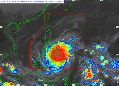
TYPHOON “ODETTE” INTENSIFIES FURTHER AND HAS MADE LANDFALL OVER SIARGAO ISLAND, SURIGAO DEL NORTE.
Location of Center (1:30 PM):
The center of the eye of Typhoon “ODETTE” was located based on all available data including those from Hinatuan and Guiuan Doppler Weather Radar in the vicinity of Siargao Island, Surigao del Norte (9.9°N, 126.1°E)
Intensity: Maximum sustained winds of 195 km/h near the center, gustiness of up to 240 km/h, and central pressure of 915 hPa
Present Movement: West Northwestward at 30 km/h
Extent of Tropical Cyclone Winds: Strong winds or higher extend outwards up to 480 km from the center
TROPICAL CYCLONE WIND SIGNALS (TCWS) IN EFFECT
• TCWS No.4 (Very Destructive typhoon-force winds prevailing or expected within 12 hours)
Visayas
-Southern Leyte, the southwestern portion of Leyte (Hilongos, Bato, Matalom), Bohol, the central and southern portions of Cebu (Lapu-Lapu City, Cordova, Cebu City, Mandaue City, Compostela, Liloan, Consolacion, Toledo City, City of Talisay, Minglanilla, City of Naga, Pinamungahan, San Fernando, City of Carcar, Aloguinsan, Barili, Sibonga, Dumanjug, Argao, Alcantara, Ronda, Moalboal, Badian, Dalaguete, Alcoy, Boljoon, Malabuyoc, Alegria)
Mindanao
-Dinagat Islands, Surigao del Norte including Siargao and Bucas Grande Islands
• TCWS No.3 (Destructive typhoon-force winds prevailing or expected within 18 hours)
Visayas
-The rest of southern portion of Leyte (Abuyog, Mahaplag, Hindang, Inopacan, City of Baybay, Javier, Macarthur), the northern portion and extreme southern portion of Cebu (Camotes Islands, Tuburan, Catmon, Carmen, Danao City, Asturias, Balamban, Samboan, Ginatilan, Oslob, Santander, Dalaguete, Sogod), Negros Oriental, Siquijor, the southern and central portions of Negros Occidental (Calatrava, San Carlos City, Salvador Benedicto, City of Talisay, Silay City, Bacolod City, Murcia, Bago City, Valladolid, Pulupandan, La Carlota City, San Enrique, La Castellana, Moises Padilla, Pontevedra, Hinigaran, Isabela, Binalbagan, City of Himamaylan, City of Kabankalan, Ilog, Cauayan, Candoni, City of Sipalay, Hinoba-An), Guimaras, the southern portion of Iloilo (Iloilo City, Pavia, Leganes, Santa Barbara, San Miguel, Alimodian, Oton, Leon, Tigbauan, Tubungan, Igbaras, Guimbal, Miagao, San Joaquin, Dumangas, Zarraga, New Lucena, Cabatuan, Maasin), and the southern portion of Antique (San Remigio, Patnongon, Belison, San Jose, Sibalom, Hamtic, Tobias Fornier, Anini-Y)
Mindanao
-The northern portion of Agusan del Norte (Kitcharao, Jabonga, Santiago, Tubay, City of Cabadbaran), and the northern portion of Surigao del Sur (Carrascal, Cantilan, Madrid, Carmen, Lanuza, Cortes, City of Tandag)
• TCWS No.2 (Damaging gale- to storm-force winds prevailing or expected within 24 hours)
Luzon
-Albay, Sorsogon, Masbate including Ticao and Burias Islands, Romblon, Oriental Mindoro, Occidental Mindoro, mainlanad Palawan including Kalayaan, Balabac, Cuyo, Calamian, and Cagayancillo Islands
Visayas
-Northern Samar, Eastern Samar, Samar, Biliran, the rest of Leyte, the rest of Cebu, the rest of Negros Occidental, the rest of Iloilo, Capiz, Aklan, and the rest of Antique
Mindanao
-The rest of Surigao del Sur, Agusan del Sur, the rest of Agusan del Norte, the extreme northern portion of Zamboanga del Norte (Dapitan City, Siayan, Sindangan, Jose Dalman, Manukan, Pres. Manuel A. Roxas, Katipunan, Sergio Osmeña Sr., Polanco, Dipolog City, Piñan, Mutia, La Libertad, Rizal, Sibutad), the extreme northern portion of Zamboanga del Sur (Josefina, Molave, Mahayag, Dumingag, Tambulig), Misamis Occidental, the northern portion of Lanao del Norte (Kolambugan, Maigo, Munai, Bacolod, Poona Piagapo, Kauswagan, Pantao Ragat, Matungao, Linamon, Baloi, Tagoloan, Pantar, Iligan City), Misamis Oriental, Camiguin, the northern portion of Bukidnon (Cabanglasan, City of Malaybalay, Lantapan, Talakag, Baungon, Libona, Manolo Fortich, Sumilao, Impasug-Ong, Malitbog), and the northern portion of Lanao del Sur (Tagoloan II, Kapai)
• TCWS No.1 (Strong winds prevailing or expected within 36 hours)
Luzon
-Catanduanes, Camarines Norte, Camarines Sur, the rest of Albay, Marinduque, the southern portion of Quezon (San Antonio, Tiaong, Candelaria, Sariaya, Dolores, Lucena City, Pagbilao, Padre Burgos, Atimonan, Agdangan, Unisan, Gumaca, Plaridel, Pitogo, Lopez, Guinayangan, Buenavista, Catanauan, General Luna, Macalelon, Mulanay, San Narciso, San Andres, San Francisco, Tagkawayan, Calauag, Quezon, Alabat, City of Tayabas, Perez), and Batangas
Mindanao
-The northern portion of Davao Oriental (Baganga, Cateel, Boston), the northern portion of Davao de Oro (Laak, Mawab, Nabunturan, Montevista, Monkayo, New Bataan, Compostela), the northern portion of Davao del Norte (Talaingod, Santo Tomas, Kapalong, Asuncion, San Isidro, New Corella), the rest of Bukidnon, the rest of Lanao del Norte, the rest of Lanao del Sur, the rest of northern portion of Zamboanga del Norte (Labason, Kalawit, Tampilisan, Liloy, Salug, Godod, Bacungan, Gutalac, Baliguian), the rest of northern portion of Zamboanga del Sur (Bayog, Lakewood, Kumalarang, Guipos, Dumalinao, Tukuran, Ramon Magsaysay, Aurora, Sominot, Tigbao, Labangan, Pagadian City, Midsalip,), and the northern portion of Zamboanga Sibugay (Titay, Ipil, Naga, Kabasalan, Siay, Diplahan, Buug)
HAZARDS AFFECTING LAND AREAS
Heavy Rainfall
• Today through tomorrow early morning: Heavy to torrential rains over Caraga, Central Visayas, Misamis Oriental, Camiguin, Southern Leyte, and Negros Occidental. Moderate to heavy with at times intense rains over Leyte, the southern portions of Eastern Samar and Samar, Zamboanga del Norte, Lanao del Sur, Davao Oriental, Davao de Oro, Davao del Norte, and the rest of Northern Mindanao. Light to moderate with at times heavy rains over Bicol Region, Quezon, and the rest of Visayas, the rest of Zamboanga Peninsula, and mainland Bangsamoro.
• Tomorrow early morning through Saturday early morning: Heavy to intense with at times torrential rains over Central Visayas, Western Visayas, and Palawan including Calamian Islands, Cuyo, and Cagayancillo Islands. Moderate to heavy with at times intense rains over Bicol Region, Zamboanga Peninsula, Quezon, Occidental Mindoro, Oriental Mindoro, Romblon, Marinduque, Lanao del Norte, Lanao del Sur, and the rest of Visayas. Light to moderate with at times heavy rains over Caraga, the southern portion of Aurora, and the rest of Northern Mindanao.
• Saturday early morning through Sunday early morning: Heavy to torrential rains over Kalayaan Islands. Light to moderate with at times heavy rains over Cagayan Valley, Aurora, Quezon, mainland Palawan and Calamian Islands.
• Under these conditions, scattered to widespread flooding (including flash floods) and rain-induced landslides are expected especially in areas that are highly or very highly susceptible to these hazard as identified in hazard maps, and in localities with significant antecedent rainfall.
Severe Winds
• Winds may reach typhoon strength up to 195 km/h in strength within any of the areas where TCWS #4 is hoisted during the passage of the typhoon. This may cause generally heavy to very heavy damage to structures and vegetation.
• Destructive typhoon-force winds will be experienced within any of the areas where TCWS #3 is in effect. This may bring moderate to heavy damage to structures and vegetation.
• Damaging winds reaching gale- to storm-force strength will be experienced within any of the areas where TCWS #2 is in effect. This may result in generally light to moderate damage to structures and vegetation.
• Strong winds (strong breeze to near gale) with higher gusts will be experienced within any of the areas where TCWS #1 is currently in effect during the passage of the typhoon. This may generally bring up to very light damage to structures and vegetation.
Coastal Inundation
There is a moderate to high risk of storm surge of up to 3.0 m in height which may cause life-threatening flooding in the low-lying coastal areas of Central Visayas, Northern Mindanao, Iloilo, Guimaras, Negros Occidental, Eastern Samar, Southern Leyte, Dinagat Islands, Surigao del Norte, Surigao del Sur, Agusan del Norte, and several localities in the northern portion of Palawan including Calamian, Cuyo and Cagayancillo Islands, Antique, the southern portion of Samar, Leyte, and Davao Oriental. For more information, refer to Storm Surge Warning #4 issued at 11:00 AM today.
HAZARDS AFFECTING COASTAL WATERS
• In the next 24 hours, moderate to very high seas (1.2 to 10.0 m) will be experienced over the seaboards of areas where TCWS is in effect (especially in the open sea areas). These conditions are risky for all types of sea vessels. Mariners are advised to remain in port or take shelter in port until winds and waves subside.
• Under the influence of Typhoon “ODETTE” and the prevailing Northeast Monsoon, a Gale Warning remains in effect for several coastal waters not under any wind signal, specifically the seaboards of Northern Luzon, and the eastern seaboards of Central and Southern Luzon. For more information, refer to Gale Warning #49 issued at 5:00 AM today.
• In the next 24 hours, moderate to rough seas (1.2 to 3.1 m) will also prevail over the remaining seaboards of the country that are not under any wind signal. These conditions are risky for those using small seacrafts. Mariners are advised to take precautionary measures when venturing out to sea and, if possible, avoid navigating in these conditions.
TRACK AND INTENSITY OUTLOOK
• Typhoon “ODETTE” has made landfall over Siargao Island, Surigao del Norte at 1:30 PM today. On the forecast track, “ODETTE” will continue moving west northwestward or westward and may make another landfall over Dinagat Islands this afternoon. Afterwards, the center of “ODETTE” will move westward and cross several provinces in Central and Western Visayas regions before emerging over the Sulu Sea tomorrow morning. After passing near or in the vicinity of either Cuyo or Cagayancillo archipelago, “ODETTE” is forecast to cross the northern or central portion of Palawan tomorrow afternoon or evening before emerging over the West Philippine Sea.
• “ODETTE” may see some slight weakening as it crosses northeastern Mindanao, Visayas, and Palawan, but it is forecast to remain as a typhoon. Re-intensification is likely once “ODETTE” emerges over the West Philippine Sea. However, weakening may ensue beginning Saturday evening or Sunday as the typhoon becomes exposed to increasing vertical wind shear and the surge of the Northeast Monsoon.
Considering these developments, the public and disaster risk reduction and management offices concerned are advised to take all necessary measures to protect life and property. Persons living in areas identified to be highly or very highly susceptible to these hazards are advised to follow evacuation and other instructions from local officials. For heavy rainfall warnings, thunderstorm/rainfall advisories, and other severe weather information specific to your area, please monitor products issued by your local PAGASA Regional Services Division.
The next tropical cyclone bulletin will be issued at 5:00 PM today.

DOST-PAGASA
Link: bit.ly/3eujmdC
For other information about weather, please log on to pagasa.dost.gov.ph or bagong.pagasa.dost.gov.ph or call at (02)927-1335/(02)926-4258


![CSC | Annex B-1 Generic and Parenthetical Titles of Positions in LGUs [PDF]](https://blogger.googleusercontent.com/img/b/R29vZ2xl/AVvXsEieGeAEX76FojmDOYXxOOfgeJHAb7eX4vRDOxnZAerslnr-FxOotLXwFHzz_4hKlTifazjxQCMtp5EOtWASCW9oAkK6FJs0P0pXRtgiH8B3OyjODObSF047Dl9FiVSCBigyzvDOHFrCo0URbwS6VDabbF1ZBtsj4PX8lq-Y_DSWZp_1nHyZM28VRQg-qLGs/s72-w640-c-h360/ANNEX%20B-1%20Generic%20and%20Parenthetical%20Titles%20of%20Positions%20in%20LGUs.jpg)

![2025 ORAOHRA [FREE DL] | CSC](https://blogger.googleusercontent.com/img/b/R29vZ2xl/AVvXsEhg4fleN1pbsPJuIStMZC0gx1Wy8uoKqqG6e0g_T5cVZsPFY9h6_ZHKnlBw-ecLllf4QH3OQBrWZDcDLqJ5wCwvnBswUPgtxarj44Av6SzfSYC0ijM_7xvJRBqqlaZRz60CfCF_-h8xMV-Kxnzbesa_CqlpKM1NAu3FM9XXBNRBGrg7s81QCXcjNY-ZuneY/s72-w640-c-h365/ORAOHRA.png)
No comments:
Post a Comment