

24-HOUR PUBLIC WEATHER FORECAST
Issued at 4:00 AM, 24 October 2021
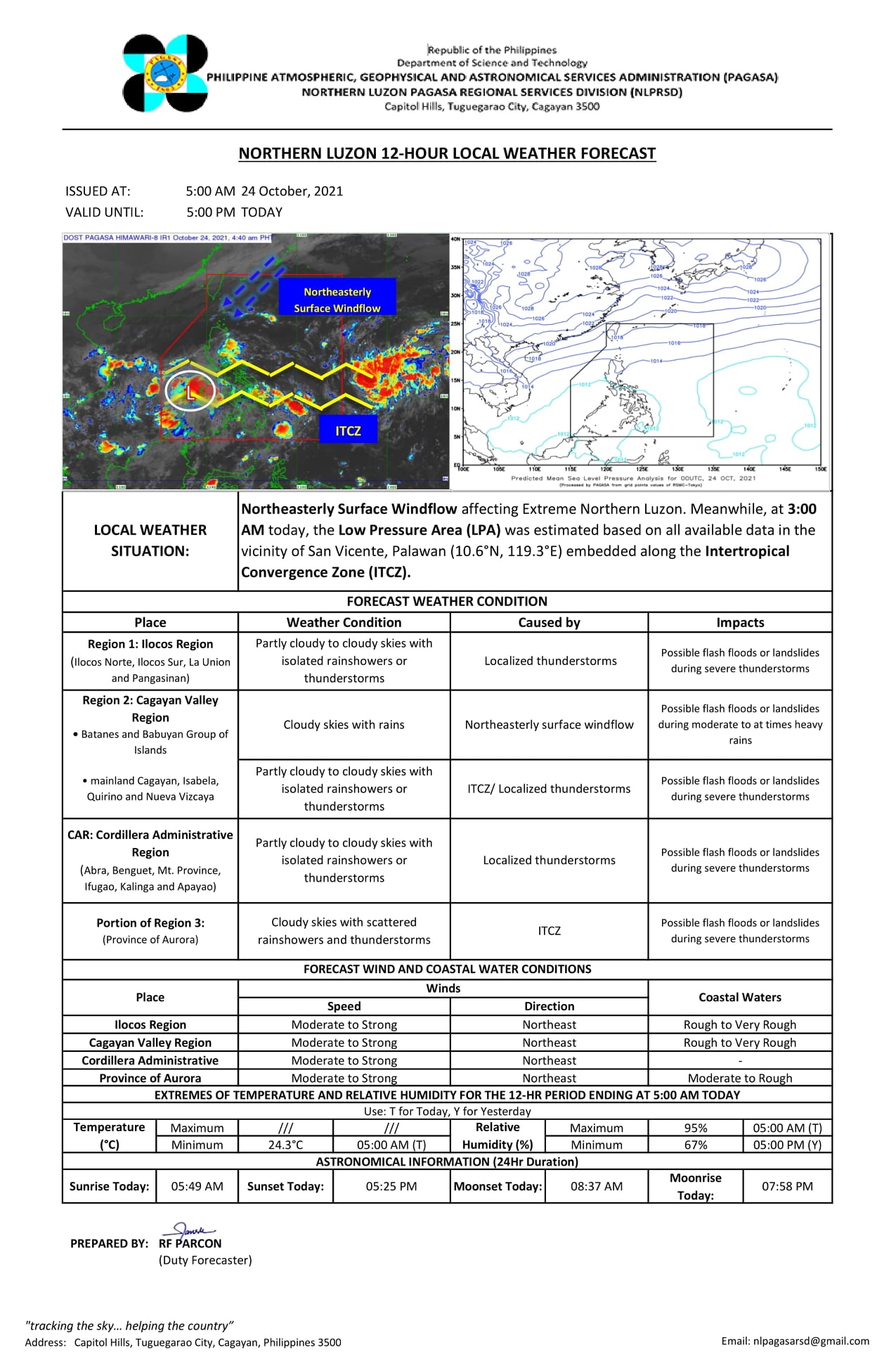
SYNOPSIS: At 3:00 AM today, the Low Pressure Area (LPA) was estimated based on all available data in the vicinity of San Vicente, Palawan (10.6°N, 119.3°E) embedded along the Intertropical Convergence Zone (ITCZ) affecting Southern Luzon, Visayas, and Mindanao.
ACTIVE TROPICAL CYCLONE OUTSIDE THE PAR AS OF 3:00 AM TODAY: TROPICAL DEPRESSION LOCATION OF THE CENTER: 1,580 KM EAST OF VISAYAS (11.4°N, 140.2°E) MAXIMUM SUSTAINED WINDS: 45 KM/H NEAR THE CENTER GUSTINESS: UP TO 55 KM/H MOVEMENT: ALMOST STATIONARY
Forecast Weather Conditions
Area: Metro Manila, Visayas, CALABARZON, MIMAROPA, Bicol
Region, and the provinces of Aurora and Bulacan
Weather Condition: Cloudy skies with scattered
rainshowers and thunderstorms
Caused By: LPA / ITCZ
Impacts: Possible flash floods or landslides during
moderate to at times heavy rains
Area: Batanes and Babuyan Islands
Weather Condition: Cloudy skies with rains
Caused By: Northeasterly Surface Windflow
Impacts: Possible flash floods or landslides during moderate
to at times heavy rains
Area: The rest of the country
Weather Condition: Partly cloudy to cloudy skies with
isolated rainshowers or thunderstorms
Caused By: ITCZ / Localized thunderstorms
Impacts: Possible flash floods or landslides during
severe thunderstorms
Forecast Wind and Coastal Water Conditions
Area: Northern and Central Luzon
Wind Speed: Moderate to Strong
Wind Direction: Northeast
Coastal Waters: Moderate to Rough / (1.2 to 4.0 meters)
Area: Palawan, Visayas, and Mindanao
Wind Speed: Light to Moderate
Wind Direction: Southwest to Southeast
Coastal Waters: Slight to Moderate / (0.6 to 2.5 meters)
Area: The rest of Luzon
Wind Speed: Light to Moderate
Wind Direction: East to Northeast
Coastal Waters: Slight to Moderate / (0.6 to 2.5 meters)
Extremes of Temperature and Relative Humidity for The
24-hour Period Ending 8:00 PM YESTERDAY
Minimum Temperature: 24.4 °C ... 5:00 AM
Maximum Temperature: 31.6 °C... 12:30 PM
Minumum Relative Humidity: 58 % ... 12:30 PM
Maximum Relative Humidity: 89 % ... 5:00 AM
TIDES AND ASTRONOMICAL INFORMATION Over Metro Manila
Low Tide TODAY: 6:49AM ... -0.05
Low Tide TODAY: 3:36PM ... 0.36
Low Tide Tomorrow: --- --- ... ---
High Tide TODAY: 1:17PM ... 0.39
High Tide TODAY: 11:34PM ... 1.00
High Tide Tomorrow: --- --- ... ---
sunrise today: 5:49 AM
sunset today: 5:31 PM
moonrise today: 8:07 PM
moonset today: 8:35 AM
illumination today: 86%
For other information about weather, please log on to pagasa.dost.gov.ph or bagong.pagasa.dost.gov.ph or call at (02)927-1335/(02)926-4258


![CSC | Annex B-1 Generic and Parenthetical Titles of Positions in LGUs [PDF]](https://blogger.googleusercontent.com/img/b/R29vZ2xl/AVvXsEieGeAEX76FojmDOYXxOOfgeJHAb7eX4vRDOxnZAerslnr-FxOotLXwFHzz_4hKlTifazjxQCMtp5EOtWASCW9oAkK6FJs0P0pXRtgiH8B3OyjODObSF047Dl9FiVSCBigyzvDOHFrCo0URbwS6VDabbF1ZBtsj4PX8lq-Y_DSWZp_1nHyZM28VRQg-qLGs/s72-w640-c-h360/ANNEX%20B-1%20Generic%20and%20Parenthetical%20Titles%20of%20Positions%20in%20LGUs.jpg)

![2025 ORAOHRA [FREE DL] | CSC](https://blogger.googleusercontent.com/img/b/R29vZ2xl/AVvXsEhg4fleN1pbsPJuIStMZC0gx1Wy8uoKqqG6e0g_T5cVZsPFY9h6_ZHKnlBw-ecLllf4QH3OQBrWZDcDLqJ5wCwvnBswUPgtxarj44Av6SzfSYC0ijM_7xvJRBqqlaZRz60CfCF_-h8xMV-Kxnzbesa_CqlpKM1NAu3FM9XXBNRBGrg7s81QCXcjNY-ZuneY/s72-w640-c-h365/ORAOHRA.png)
No comments:
Post a Comment