TROPICAL CYCLONE BULLETIN NR. 1
Tropical Depression #DantePH
Issued at 5:00 PM, 22 July 2025
Valid for broadcast until the next bulletin at 11:00 PM today.
THE LOW PRESSURE AREA EAST OF AURORA DEVELOPED INTO TROPICAL DEPRESSION “DANTE”
• Location of Center (4:00 PM): The center of Tropical Depression DANTE was estimated based on all available data at 1,115 km East Northeast of Central Luzon or 1,130 km East of Northern Luzon (18.3°N, 132.4°E).
• Intensity: Maximum sustained winds of 45 km/h near the center, gustiness of up to 55 km/h, and central pressure of 1000 hPa
• Present Movement: North northwestward at 20 km/h
• Extent of Tropical Cyclone Winds: Strong winds extend outwards up to 220 km from the center
TROPICAL CYCLONE WIND SIGNALS (TCWS) IN EFFECT
• No Wind Signal currently hoisted.
OTHER HAZARDS AFFECTING LAND AREAS
• Heavy Rainfall Outlook
Refer to Weather Advisory No. 29 issued at 5:00 PM today for the heavy rainfall outlook due to the Southwest Monsoon enhanced by DANTE, the Low Pressure Area east of Batanes, and Tropical Cyclone WIPHA over Vietnam
• Severe Winds
The enhanced Southwest Monsoon will bring strong to gale-force gusts over the following areas (especially in coastal and upland areas exposed to winds):
• Today: Zambales, Bataan, Metro Manila, CALABARZON, MIMAROPA, Visayas, and Dinagat Islands
• Tomorrow (23 July): Ilocos Region, Zambales, Bataan, Bulacan, Metro Manila, CALABARZON, MIMAROPA, Visayas, Zamboanga del Norte, Misamis Occidental, Lanao del Norte, Camiguin, and Dinagat Islands.
• Thursday (24 July): Ilocos Region, Abra, Benguet, Central Luzon, Metro Manila, CALABARZON, MIMAROPA, Visayas, Zamboanga del Norte, Misamis Occidental, Lanao del Norte Camiguin, and Dinagat Islands.
HAZARDS AFFECTING COASTAL WATERS
• 24-Hour Sea Condition Outlook
Up to rough seas over the following coastal waters:
• Up to 3.0 m: The seaboards of Batanes and Kalayaan Islands; the western seaboards of Zambales, Bataan, Lubang Island, Occidental Mindoro, and Calamian Islands.
• Mariners of small seacrafts, including all types of motorbancas, are advised not to venture out to sea under these conditions, especially if inexperienced or operating ill-equipped vessels.
Up to moderate seas over the following coastal waters:
• Up to 2.5 m: The seaboards of Babuyan Island and Ilocos Region; the southern seaboard of Bataan; the western seaboards of Cavite, Batangas, and Palawan.
• Up to 2.0 m: The seaboards of Camarines Norte, Oriental Mindoro, Marinduque, and Romblon; the northern and eastern seaboards of Catanduanes and Northern Samar; the eastern seaboards of Albay, Sorsogon and Davao Oriental; the western seaboard of Masbate; the southern seaboard of Quezon; the remaining seaboard of Batangas and Occidental Mindoro; the northern seaboard of Camarines Sur.
• Mariners of motorbancas and similarly-sized vessels are advised to take precautionary measures while venturing out to sea and, if possible, avoid navigation under these conditions.
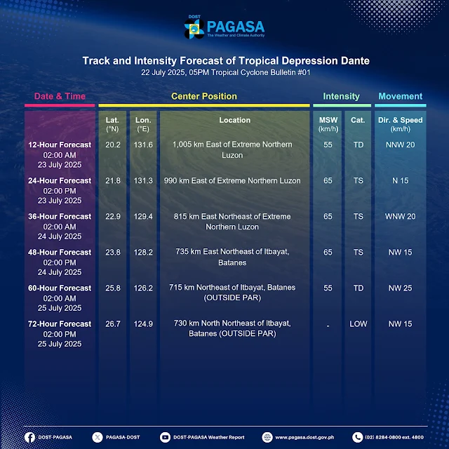
TRACK AND INTENSITY OUTLOOK
• DANTE is forecast to move northward or north northwestward over the Philippine Sea from tonight to tomorrow (23 July), before turning northwestward towards the Ryukyu Islands and the East China Sea. On the track forecast, DANTE may exit the Philippine Area of Responsibility (PAR) on Thursday (24 July) or on Friday (25 July).
• DANTE may reach tropical storm category tomorrow. Further intensification into a severe tropical storm remains less likely but is not ruled out.
Considering these developments, the public and disaster risk reduction and management offices concerned are advised to take all necessary measures to protect life and property. Persons living in areas identified to be highly or very highly susceptible to these hazards are advised to follow evacuation and other instructions from local officials. For heavy rainfall warnings, thunderstorm/rainfall advisories, and other severe weather information specific to your area, please monitor products issued by your local PAGASA Regional Services Division.
The next tropical cyclone bulletin will be issued at 11:00 PM today.
DOST-PAGASA


![2025 ORAOHRA [FREE DL] | CSC](https://blogger.googleusercontent.com/img/b/R29vZ2xl/AVvXsEhg4fleN1pbsPJuIStMZC0gx1Wy8uoKqqG6e0g_T5cVZsPFY9h6_ZHKnlBw-ecLllf4QH3OQBrWZDcDLqJ5wCwvnBswUPgtxarj44Av6SzfSYC0ijM_7xvJRBqqlaZRz60CfCF_-h8xMV-Kxnzbesa_CqlpKM1NAu3FM9XXBNRBGrg7s81QCXcjNY-ZuneY/s72-w640-c-h365/ORAOHRA.png)


No comments:
Post a Comment