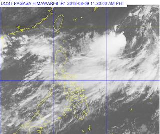
"KARDING" HAS SLIGHTLY SLOWED DOWN AND IS NOW MOVING NORTHWESTWARD.
"KARDING" is not expected to make landfall in any part of the country.Meanwhile, at 10:00 AM today, the Low Pressure Area (LPA) over the West Philippine Sea was estimated at 950 km West of Northern Luzon (17.0°N, 111.7°E) (OUTSIDE PAR).
This Tropical Storm and the aforementioned LPA may enhance the Southwest Monsoon (Habagat) which will bring scattered to widespread moderate to heavy rains over Northern and Central Luzon, especially over the western section, beginning tomorrow (10 August). Residents of these areas, especially those living near river channels, in low-lying areas, and in mountainous areas, are advised to take appropriate actions against possible flooding and landslide, coordinate with local disaster risk reduction and management offices, and continue monitoring for updates.
Sea travel remains risky over the western seaboard of Luzon.
Location of eye/center: At 10:00 AM today, the center of Tropical Storm "KARDING" was estimated based on all available data at 1,200 km East of Basco, Batanes (21.0 °N, 133.5 °E)Forecast Positions:
Strength: Maximum sustained winds of 65 km/h near the center and gustiness of up to 80 km/h
Forecast Movement: moving Northwest
- 24 Hour(Tomorrow morning): 1,210 km East Northeast of Basco, Batanes(23.6°N, 133.2°E)
- 48 Hour(Saturday morning):1,130 km Northeast of Basco, Batanes(26.7°N, 130.7°E)
- 72 Hour(Sunday morning): 1,130 km North Northeast of Basco, Batanes(29.7°N, 126.6°E)
- 96 Hour(Monday morning):1,465 km North of Basco, Batanes(33.5°N, 124.0°E)
Weather information is courtesy of DOST PAGASA.


No comments:
Post a Comment