

Issued at 5:00 AM, 10 NOVEMBER 2020
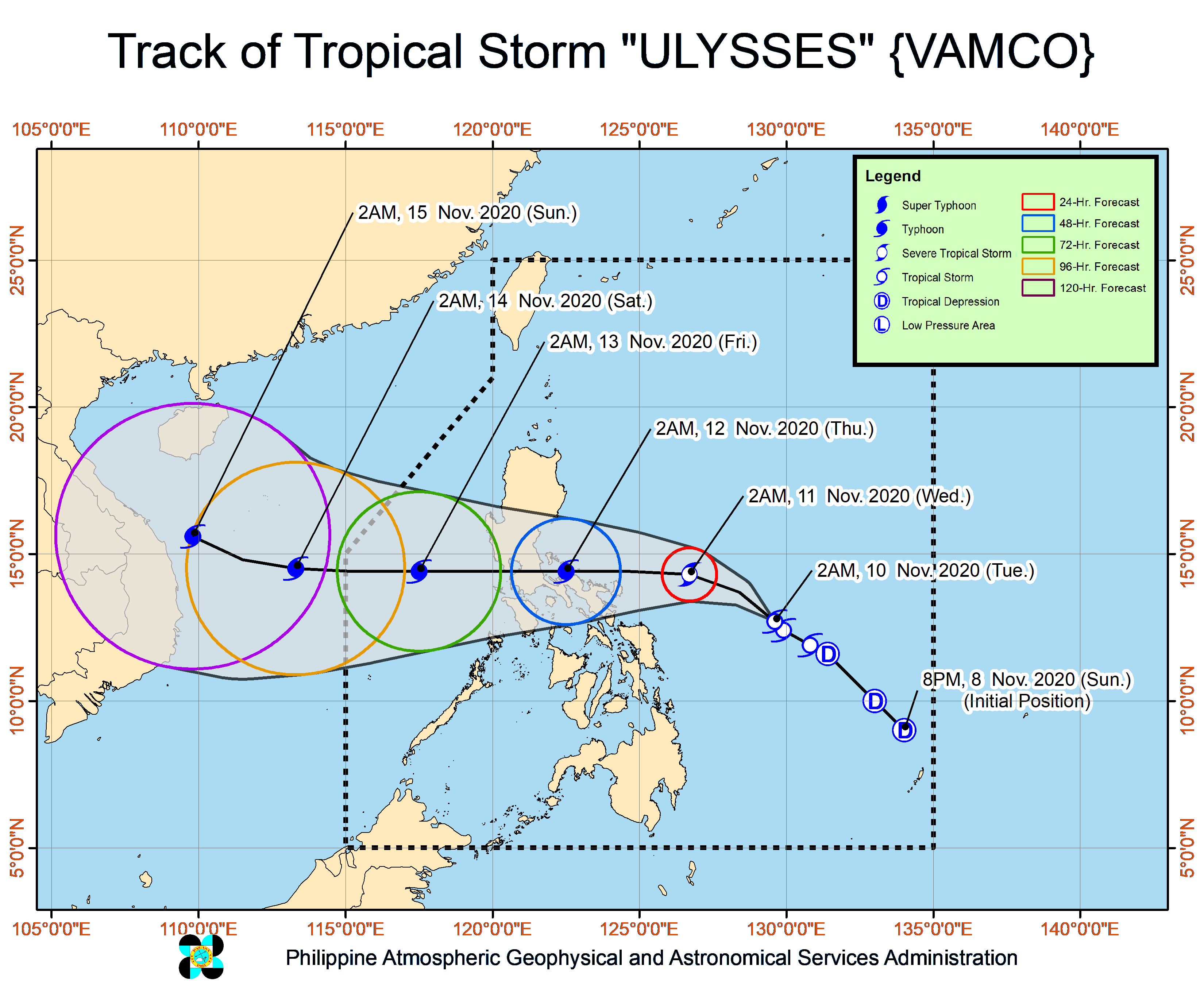
Synopsis: At 4:00 AM today, the center of Tropical Storm "ULYSSES" was estimated based on all available data at 555 km East of Virac, Catanduanes (12.9 °N, 129.3 °E ) with maximum sustained winds of 65 km/h near the center and gustiness of up to 80 km/h moving Northwestward Slowly.
TROPICAL STORM "ULYSSES" HAS SLOWED DOWN WHILE MOVING NORTHWESTWARD.
Track and Intensity Outlook:
Track: On the forecast track, Tropical Storm “ULYSSES” will move generally northwestward today, then turn more westward tomorrow. On the forecast track, the center of “ULYSSES” is more likely to make landfall over Quezon on Thursday morning, with a close approach of Catanduanes and Camarines Norte tomorrow afternoon and evening, respectively. However, the slight shift in the orientation of the track forecast shows an increasing likelihood of landfall over Bicol Region tomorrow afternoon or evening.
Intensity: “ULYSSES” is forecast to intensity into a severe tropical storm tonight. Owing to favorable conditions, this storm may reach typhoon category by tomorrow morning and reach its peak intensity (140-155 km/h) tomorrow afternoon or evening. Landfall at or near peak intensity is highly likely.
Forecast Position
24 Hour(Tomorrow morning): 280 km East Northeast of Virac, Catanduanes(14.3°N, 126.7°E)
48 Hour(Thursday morning):60 km West Northwest of Daet, Camarines Norte or 60 km East Northeast of Alabat, Quezon( 14.4°N, 122.5°E)
72 Hour(Friday morning): 370 km West of Sangley Point, Cavite City, Cavite( 14.4°N, 117.5°E)
96 Hour(Saturday morning):820 km West of Southern Luzon (OUTSIDE PAR)( 14.5°N, 113.3°E)
120 Hour(Sunday morning):1,090 km West of Central Luzon (OUTSIDE PAR)( 15.6°N, 109.8°E)
Hazards affecting land areas:
Strong winds: In anticipation of the onset of strong breeze to near gale conditions associated with “ULYSSES”, Tropical Cyclone Wind Signal (TCWS) #1 is now in effect over more localities in CALABARZON, Bicol Region, and Eastern Visayas. More areas in these regions will be placed under TCWS #1 in the next bulletin. TCWS #2 may be hoisted in some areas of Bicol Region as early as tonight. Based on the intensity forecast, the highest wind signal to be hoisted during the passage of “ULYSSES” will be TCWS #3.
Wind Signal (Areas with TCWS)
Tropical Cyclone Wind Signal no. 1
Luzon:
Catanduanes, Camarines Norte, Camarines Sur, Albay, Sorsogon, the eastern portion of Masbate (Aroroy, Pio V. Corpuz, Cataingan, Palanas, Uson, Dimasalang, Masbate City, Mobo, Baleno) including Ticao and Burias Islands, and the southeastern portion of Quezon (Guinayangan, Tagkawayan, Buenavista, San Andres, San Narciso)
Visayas:
Northern Samar, the northern portion of Samar (Santo Nino, Almagro, Tagapul-An, Tarangnan, Calbayog City, Santa Margarita, Gandara, Pagsanghan, San Jorge, San Jose de Buan, Matuguinao), and the northern portion of Eastern Samar (Maslog, Dolores, Oras, San Policarpo, Arteche, Jipapad)
For other information about weather, please log on to www.pagasa.dost.gov.ph or bagong.pagasa.dost.gov.ph or call at (02)927-1335/(02)926-4258
ARTICLE: [Download Full PAGASA REPORT]
Salary Standardization Law of 2019 for 2020 - 2023.
Teacher's Compensation FY 2020-2023 as per Salary Standardization Law of 2019.
Weather Motion Graph brought to you by: Windy.com
Sources:
[1] DOST-PAGASA: http://bagong.pagasa.dost.gov.ph/weather#daily-weather-forecast
[2] Windy Motion Graph: https://www.windy.com/?14.628,121.046,
Sources:
[1] DOST-PAGASA: http://bagong.pagasa.dost.gov.ph/weather#daily-weather-forecast
[2] Windy Motion Graph: https://www.windy.com/?14.628,121.046,


![CSC | Annex B-1 Generic and Parenthetical Titles of Positions in LGUs [PDF]](https://blogger.googleusercontent.com/img/b/R29vZ2xl/AVvXsEieGeAEX76FojmDOYXxOOfgeJHAb7eX4vRDOxnZAerslnr-FxOotLXwFHzz_4hKlTifazjxQCMtp5EOtWASCW9oAkK6FJs0P0pXRtgiH8B3OyjODObSF047Dl9FiVSCBigyzvDOHFrCo0URbwS6VDabbF1ZBtsj4PX8lq-Y_DSWZp_1nHyZM28VRQg-qLGs/s72-w640-c-h360/ANNEX%20B-1%20Generic%20and%20Parenthetical%20Titles%20of%20Positions%20in%20LGUs.jpg)


No comments:
Post a Comment